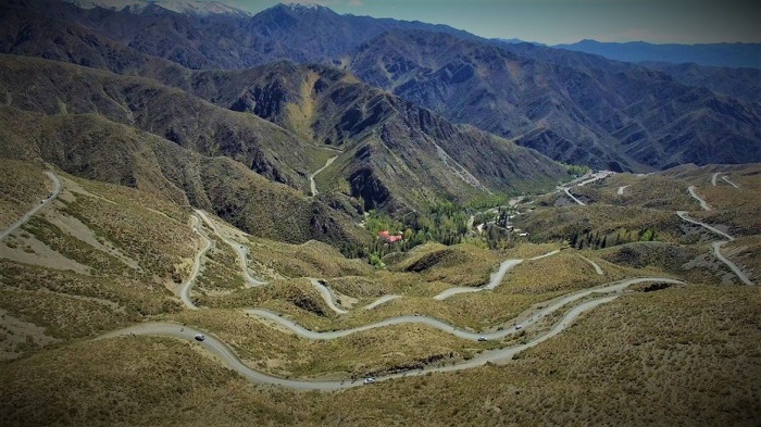
RP 52 joins the department of Las Heras with Uspallata in a gravel road that runs through dry riverbeds and stony areas. It is relatively low difficulty, reaching up to 3,200 m and its route is 72 km (3 hs approx.)
This route is part of the circuit of local adventure tourism where endurists, trucks, quads, mountain bikers usually frequent in search of challenging nature.
With the supervision of the Mendocina Mountain Cycling Association, the most anticipated crossing for Mendoza bikers arrives, which begins at the historic Canota Monument, located at kilometer 36 of Provincial Route 52, a historical symbol during the crossing of the Andes. This monument is located in an extensive piedmont that allows to have a fantastic view of the Precordillera. From this point the runners start upwards through the foothills. In just 55 km of travel, the road reaches 1600 masl, typical of this Andean region, followed by a stretch of sunny slopes and precipices that reach 2700 meters above sea level. The curves follow and back, almost imperceptible is the starting point and Vaquerías. At this point, cyclists start the winding journey, until we reach the old Telegrafo and the Ruins of the Hornillos that mark the end of the snails, but we are not close to having finished the trip because, as if that were not enough, the puna also says present. El Mirador del Balcón is the next stop. It is a geological fault, a huge crack of about 80 meters. Later on we will get to the Cruz de Paramillos and a few meters away, the Mirador del Aconcagua, a privileged place to observe the colossus of America. A sign indicates that we are at 3,200 meters above sea level, the highest point of the route and also the end point of the Reserve. After a descent with a steep slope and a dozen more kilometers, you reach the Agua de la Cerraja lagoon. And from there it is followed by a simple path to Uspallata.
An adventure among cornices, little valleys and elaborate snails, to which neither locals nor visitors can refuse. Also during the crossing, with an attentive eye maybe the runners may cross with a guanaco or a fox, and surely see small birds of height that stop at the side of the road. But nothing of distractions since it is transited by cornices in radical ascent. Therefore, it is recommended that runners stop only at the authorized sites, since other vehicles travel in both directions.
With respect to the race itself, it is not a road cycling race. The modality is called height mischief, therefore the runner is not allowed from a vehicle and the same runner will have to be satisfied with water and other foods (the organization can provide hydration only in the positions agreed for that purpose). However throughout the journey there are collaborators (especially in the descent sections) to help runners who need it and control the traffic of other vehicles.
The participants will be classified into three categories: the junior category will cover a 40 km section, starting at Los Hornillos, the next category will have a 57 km long circuit that starts at the Villavicencio Park Ranger Station and finally the amateurs that are available To complete the crossing, you must travel 72 km from the Canota Monument. The point of arrival for all participants is
the Municipal Camping of the Villa of Uspallata.


