11-Jesús Nazareno
It is limited in the north by the East Access Avenue, in the east by the Pescara Canal, in the south by the street San Francisco del Monte, and in the west by Curupayti Street.
With an area of 3.63 square kilometres and a population of 6875 inhabitants, its population density is 1894 inhabitants per square kilometre.
There are two schools, two health centres, and there are no police stations or police departments.
The commercial activity of this area is related to the Wine Industry, processing of olives, and timbers yard.
The South Access Avenue works as an inter-departmental road. Its main roads are San Francisco del Monte, Elpidio González, Curupayti, and Tapón Moyano. Its secondary roads are Castro, Adolfo Calle, and Jesús Nazareno.
History: Like in the olden times, the old bells of the chapel at the square, forged in 1883, continue calling the families who constitute the permanent population of the area to the mass. One of the most stunning constructions and of great interest is the chapel, a classic construction of the XIX century, constructed with adobe bricks, cane, mud, ceiling with hand made roof truss and gable roof. As time passed by its structure was modified due to the inclemencies of the time. This district was settled in lands that originally belonged to Don Felix Pescara and his wife Mrs. Escolástica Ilarnes. In the past, the construction of a chapel in their land was a habit among the families who had properties. This was to invocate Jesús Nazareno.
12-Rodeo de la Cruz
It is limited in the north by the street San Francisco del Monte, in the east by the streets Concordia and Milagros, in the north by the General San Martin Railroad and by the Pescara Canal, and in the west by the Pescara Canal.
With an area of 8 square kilometres and a population of 19053 inhabitants, its population density is 2382 inhabitants per square kilometre.
There are five schools, a police station and two health centres.
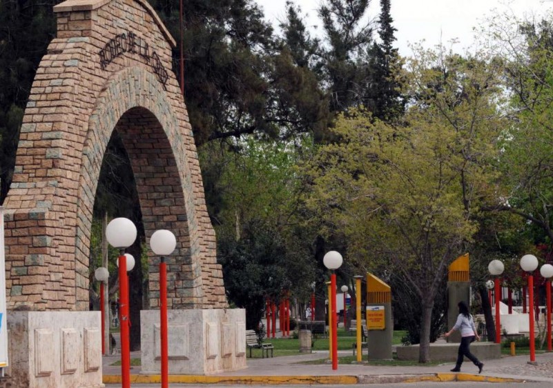
Nowadays Rodeo de la Cruz is an important pole of industrial and commercial development, where stand out the production of balanced food, glass containers, coachwork, nutritional articles, home appliances, bicycles, mosaics, fireworks and pumping equipment, among others. In addition, there is the breeding and sale of pigs, rabbits and birds. The municipality of Guaymallén keeps in this district the Cultural Centre “Pascual Lauriente”, that holds different cultural, educational, social and tourist activities. Its building has a covered area of 750 square metres, and it was inaugurated by the commune on May 14 1993. Moreover, the square denominated “the Arc” also characterizes the area. It is located on the Carril Nacional and Agustín Alvarez, and its construction dates back from 1940. Its complete remodelling done by the municipality was finished in November of 1993. To this traditional construction, there were annexed recreational areas, a circus, colonial lampposts, and different trees and bushes species.
The street Carlos Ponce is the inter-departmental communication route. The main routes are Elpidio González, San Francisco del Monte, and Bandera de los Andes. The secondary ones are Famatina, Pichincha, Congreso, and Solari.
History: When the Department of Guaymallén was created by the decree of May 14 1858, the district of Rodeo de la Cruz was delimited. At that time, there were few houses in the area, which was almost completely agricultural. By that time, the crops of corn, wheat and other grains, as well as different kinds of vegetables would stand out. There used to be pasturing fields where the troopers would take their herd to recover after a long trip and to get protection from the harsh winter.
In 1884, the construction of the railway branch that crosses the district began, which was a fact of great importance for the zone. The engineers in charge of the railway work built some houses along the Carril Nacional. Those constructions were predominantly in a defined English style that contrasted with the colonial architecture of the houses of the first settlers. Shortly after, with the arrival of the immigrants, the architecture of the district suffered a number of variations predominating the Italian style. In the registries of the Ecclesiastical History of Cuyo it is determined that in the early 1750 there already was the village called Rodeo de la Cruz, which was dependent of the parish of the city of Mendoza, thus justifying its antiquity and the cattle activity.
It was customary in those distant times to call the main farms “rodeo” and to add to the name of its proprietors as well. This area since 1663 was a property of the family De la Cruz, and that is the reason for the district denomination.


